Sulawesi Map
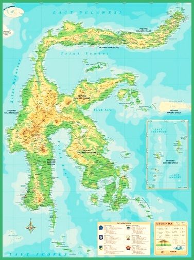
Sulawesi Map – Sulawesi is included in 5 a big island in Indonesia that has a very unique shape, which Sulawesi has many bays and headlands. Regarding the Sulawesi map, see our discussion of the Complete Sulawesi Map Material 6 Province and Description below.
Table of Contents
Sulawesi Map
Sulawesi is included in 5 a big island in Indonesia that has a very unique shape, which Sulawesi has many bays and headlands.
If we look clearly at the map of Sulawesi, You can see the unique shape of the island, which is like a human finger, different from the shape of other islands in Indonesia.
Based on the year census 2005, population or population of the island of Sulawesi, namely there are approx 16 million souls, with population density 92 soul/ km2. As for 2 Sulawesi's newest province was formed in 2000 & 2004.
The island which has the name Celebes island is in fourth place based on its area and population.
Sulawesi has its own history so that it is named the island of Sulawesi which is connected with the iron ore trade, here's the review.
other than that, Currently the island of Sulawesi is divided into 6 province by the government of the Republic of Indonesia. Read Also : Indonesian map
Sulawesi Map Image
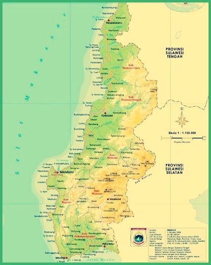
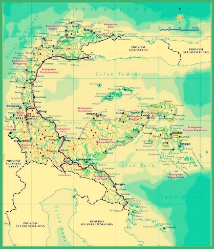
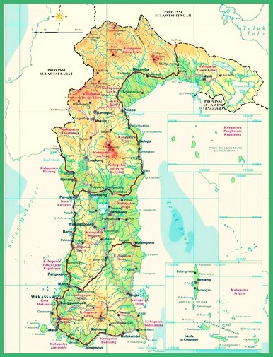
The following is an image of a complete map of Sulawesi with 6 the province in which Sulawesi is among them, West sulawesi map, Central Sulawesi Map, South Sulawesi Map, north sulawesi map, southeast sulawesi map, and gorontalo map.
1. Complete Sulawesi Map
2. West Sulawesi Map
3. Central Sulawesi Map
4. South Sulawesi Map
5. North Sulawesi Map
6. Southeast Sulawesi Map
7. Gorontalo Map
Read Also : World map
Provinces In Sulawesi
Sulawesi was originally only composed of 4 province, namely South Sulawesi, North, Central and Southeast Sulawesi.
Later in the year 2000 there is the expansion of Gorontalo as a new province in Sulawesi, and then followed the province of West Sulawesi in 2004.
The following are the names of the provinces on the island of Sulawesi, Indonesia, along with the explanation :
1. West Sulawesi
West Sulawesi, which is a new province in Sulawesi, is located in the western part of the island, which sulawesi baarat has the capital city in the city of Manuju.
West Sulawesi has an area of 16.796,19 Square km, with a population of up to 1.158.336 which number of souls are scattered in 6 districts.
The determination of the West Sulawesi region to be the latest province occurred or was carried out on 5 October 2004.
2. North Sulawesi
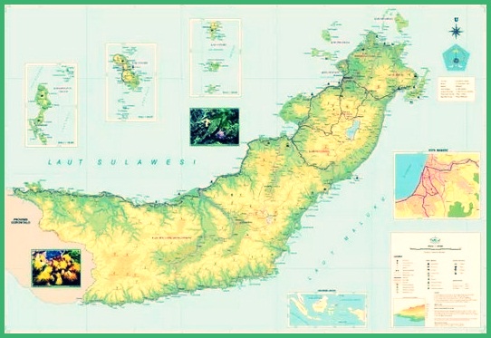
North Sulawesi is a province of Sulawesi which is located at the northern tip of this island, Manado is the capital city.
Which one of these north sulawesi has 11 district and 4 the city that is the administrative area. The districts in North Sulawesi include:,
- Mongondow,
- North Mongondow,
- Sangihe,
- Hello Tagulandang ,
- Mogndow Sleatan,
- East Mongondow,
- Talaud, Southeast Minahasa,
- Minahasa,
- South Minahasa,
- North Minahasa.
In addition to the district of North Sulawesi, it also has a city that, where the number of cities is 4, as for the city that is :
- Bitung City,
- Kotamobagu,
- Manado,
- Please.
other than that, North Sulawesi has great historical tourism potential which is part of national and even world history.
To find out more clearly, you can look back at the map of North Sulawesi above.
3. Central Sulawesi
Central Sulawesi Province is a province consisting of 12 district and 1 a city you can explore, this province is in the center of the island.
The provincial capital of Central Sulawesi is Palu, Central Sulawesi has an area of 61.841,29 Square km, and with the total population 2.831.283 soul.
Central Sulawesi Province is the largest province compared to other provinces in Sulawesi, province in Sulawesi, with the second largest population.
4. South Sulawesi
South Sulawesi is a province in Indonesia which is located in the southern part of Sulawesi. The capital city is Makassar.
other than that, South Sulawesi province with the capital city in Makassar, formerly called Ujung Pandang.
South Sulawesi has 12 district and 3 kota, its astronomical location is 0 level 12 LS minutes- 116 level 48 minute-22 degrees 36 BT minutes.
If we pay attention, on the map of Sulawesi this province is at the southern tip of the island. Where this province has an area of 45764,53 Square km, and a population of 8.034.776 soul.
5. Southeast Sulawesi
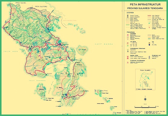
Southeast Sulawesi is a province in Indonesia which is located in the southeastern part of the island of Sulawesi with the capital city Kendari.
Geographically, South Sulawesi is located south of the equator in 02 level 45 minute-06 level 15 LS minutes and 120 level 45 minutes-124 degrees 30 BT minutes.
South Sulawesi has an area of 38.140 Square km with a population or population reaching 2,5 million souls.
6. Gorontalo
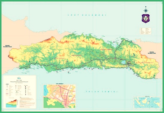
Gorontalo Province is the third province 32 in Indonesia which has been set in 5 December 2000.
Where the province of Gorontalo is located in the northern part of the province of North Sulawesi. And has the provincial capital of the same name that is, Gorontalo City
Gorontalo is also known as the porch of Medina. The total area is 12.435 sq km with 5 district and 1 kota. Regencies and cities in the province of Gorontalo are: :
- Boalemo Kabupaten County,
- Bone Bolango, Gorontalo,
- North Gorontalo,
- Pohuwato and Gorontalo kota city.
If you look at the map of Sulawesi clearly, it will be seen that this province is the smallest province in Sulawesi.
Sulawesi Territory Boundary
Indonesia has 5 the big island, namely the island of Java, the island of Sumatra, Kalimantan island, Papua Island, and the island of sulawesi, and 5 the island has territorial boundaries.
The boundaries of the Sulawesi Archipelago are as follows: :
- To the south, it is bordered by the Flores Sea
- To the southeast it is bordered by the Banda Sea
- To the north, it is bordered by the Sulawesi Sea
- To the west, it is bordered by the Makassar Strait
- To the east, it is bordered by the Maluku Sea
The land area of the island of Sulawesi is 174.000 Square Km. With a unique shape that is like a spider rose or like the letter K.
Which is a longitudinal shape from north to south with 3 longitudinal peninsula towards the northeast, east east and also southeast.
The island of Sulawesi itself is bounded by the Makassar Strait in the west which is separated from Kalimantan and is also separated from the Maluku islands from the Maluku Sea.
The island of Sulawesi is bordered by Borneo in the west. Meanwhile, to the north, it is bordered by the Philippines, south with Flores, and in the east are Southeast Timor and Maluku.
With the area 174.600 Km2 and with the coordinate point at 2°08′ LU and 170°17′ BT.
Sulawesi Island Boundary
The following are the boundaries of the island of Sulawesi and the names of the seas, Beach, Mountains, and Mainland. Judging from the geographical conditions of Sulawesi Island, the following are the boundaries between the sea and the land::
1. Sea Boundary
| Area | Limit |
| Eastern Part | Banda Sea |
| Eastern Part | Makassar Strait |
| South side | Sulawesi Sea |
| Northern part | Flores Sea |
2. Mainland Boundaries
| Area | Borderline |
| Eastern Mainland | Maluku Islands |
| West Mainland | Kalimantan island |
| South Mainland | NTT and NTB Pulau Islands |
| Northern Mainland | Philippines |
Based on geographical conditions, Sulawesi Island which has an area of 174.600 km2. Where the coordinates of the point are 2°08′ LU & at 170°17′ BT.
For the sea boundary on the island of Sulawesi, namely in the eastern area is the Banda Sea. The western area is the Makassar Strait, the northern area of the Celebes Sea and the southern area, namely the Flores Sea.
1. West Sulawesi
2. North Sulawesi
3. Central Sulawesi
4. South Sulawesi
5. Southeast Sulawesi
6. Gorontalo

That's our explanation Material Sulawesi Map Complete 6 Province and Description. Don't forget to always visit our website so that you can get a lot of knowledge. Read Also : Southeast Asia Map. Thank you.
The post Peta Sulawesi appeared first on YukSinau.co.id.
