Palembang Map
Palembang city is one of the cities which is also the capital of the province of South Sumatra. Palembang is the 2nd largest city in Sumatra after Medan City. For more details, see the Palembang Map Material Complete with the description below.
Table of Contents
Palembang city map
Palembang city is one of the cities which is also the capital of the province of South Sumatra. Palembang is the 2nd largest city in Sumatra after Medan City.
Palembang City has another designation, namely Venice of the East, based on the Kedukan Bukit inscription found on Siguntang Hill which is to the west of Palembang City.
Which in this case states the formation of a wanua which is declared as a city on the date 16 June 682 BC, which later became the day used as a benchmark for Palembang City's birthday.
The city of Palembang currently has no 18 district with 107 ward (which of the total 236 subdistrict, 386 village and 2.853 villages throughout South Sumatra).
The population of Palembang City is 1.569.297 soul with its territory 369,22 km² with population distribution 4.250 lives/km²
Geographically, Palembang city is located at 2°59′27.99 ″LS 104°45′24.24″BT. Palembang city has an area of 358,55 Km² with height 8 meters from sea level.
The location of Palembang is quite strategic because it is traversed by the Trans Sumatra road that connects between regions on the island of Sumatra.
Palembang itself can be reached by air or via flights from various cities in Indonesia such as :
- Bandar Lampung,
- Bengkulu,
- Pinang base,
- Tanjung Pandan (via Pangkal Pinang),
- Jambi,
- Lubuk Linggau,
- Jakarta, Bandung,
- Yogyakarta,
- Surabaya,
- Padang,
- Pekanbaru,
- Batam,
- While,
- Denpasar-Bali. Dll..
As for those from abroad, namely Singapore, Kuala Lumpur, as well as Jeddah (Hajj season).
In addition, the city of Palembang has a very famous river, namely the Musi River which is crossed by the Ampera Bridge and serves as a means of transportation and trade between regions..
The Musi River is a river that has a length of approx 750 km which divides the city of Palembang into two parts, namely Seberang Ulu and Seberang Ilir is the longest river on the island of Sumatra.
Read Also : Indonesian map
Palembang City Map Image
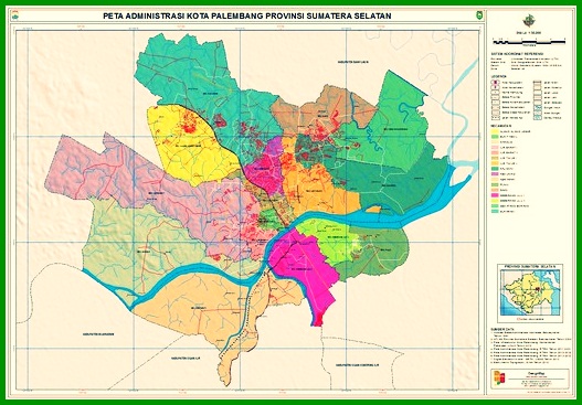
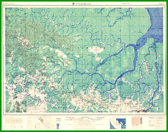
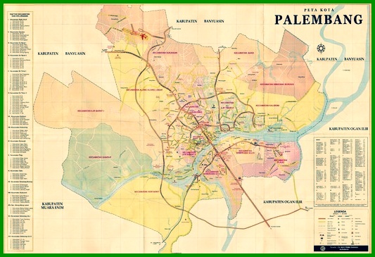
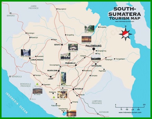
The following is a picture of the palembang map covering, administrative map of palembang city, palembang topographic map, complete palembang city map, the following :
1. Palembang City Administration Map

2. Palembang Topographic Map

3. Palembang city map

4. Palembang Map

Read Also : World map
History of Palembang City
History of the city of Palembang where this city was once the capital of the largest Buddhist maritime empire in Southeast Asia at that time.
Kingdom of Srivijaya, dominating the archipelago & Peninsular Malaya in the 9th century which also makes this city known by its nickname “Srivijaya Earth”.
This is evidenced by the preservation of one of the arts to date, namely the Palembang songket.
The Kedukan Bukit inscription which has been found on Siguntang Hill which is west of Palembang City, which states the formation of a wanua which is interpreted as a city on date 16 June 682 BC.
Which makes Palembang the oldest city in Indonesia. In the West, Palembang city is also nicknamed Venice of the East (“Venice of the East”).
This city became the center of the Sriwijaya kingdom, Attack of the Rajendra Chola who came from the Chola Kingdom in 1025, causing this city to only become a simple harbor and even meaningless to foreign merchants.
Based on the Chinese chronicle name Pa-lin-fong which is written in the book Chu-fan-chi written in 1178 by Chou-Ju-Kua referred to Palembang.
Based on the story of the Babad Arya Tabanan and the Song of Pamacangah, it is mentioned that a character from Kediri named Arya Damar became the regent of Palembang.
Arya Damar also participated in conquering Bali together with Gajah Mada, Mahapatih Majapahit in 1343.
Around the year 1513, Tome Pires who was an adventurer from the Portuguese Region mentioned Palembang, which was led by a governor appointed from Java who was later referred to the Demak sultanate and participated in carrying out the attack against Malacca which at that time had been controlled by the Portuguese..
Palembang emerged as a sultanate in 1659 with Sri Susuhunan Abdurrahman who became the first king.
Then, in the year of 1823 the Palembang sultanate was abolished by the Indian government – Dutch.
Which after that Palembang was divided into 2 The large residences and settlements in Palembang were divided into the Ilir area and the Ulu . area.
At the date of 27 September 2005, The city of Palembang has been implemented by the 6th President of the Republic of Indonesia, namely Susilo Bambang Yudhoyono as a “Water Tourism City”.
Then, in year 2008 Palembang welcomes tourist visits with the name “Visit Musi 2008”.
The city of Palembang has just become one of the cities implementing sports sports parties 2 annual event in Southeast Asia, namely the XXVII SEA Games 2011.
Read Also : Southeast Asia Map
That's our explanation of the Palembang Map Material. Don't forget to always visit our website so that you can get a lot of knowledge. Read Also : Map of Lampung. Thank you.
The post Peta Palembang appeared first on YukSinau.co.id.
