East Java Map
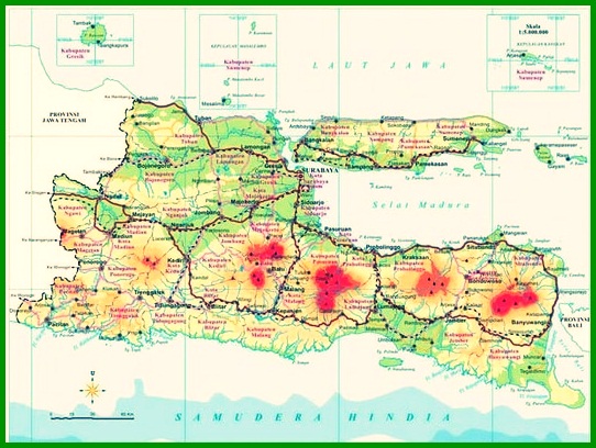
East Java Map – East Java map is a map of the island of Java and has a very wide area. This area covers the eastern part of Java which is famous for its very beautiful natural panorama.. Regarding the map of East Java, see the East Java Map Material Complete with Regency and City Names below.
Table of Contents
East Java Map
East Java map is a map of the island of Java and has a very wide area. This area includes the eastern part of Java which is famous for its very beautiful natural panorama and many exotic natural scenery.
Based on regional boundaries, the western part of East Java is bordered by Central Java, To the east, it is bordered by the island of Bali.
And the northern part of the Java Sea, and to the south by the Indian Ocean.
This East Java map has an area of approx 47.922 km² with population based on Indonesia Population Projection data 2010-2035 carried out by the National Development Planning Agency (IBRA) and the Central Statistics Agency (BPS) on 2013.
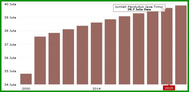
The population of East Java currently reaches approx 37,47 million souls, which means to grow 8% from the results of the Population Census 2000, i.e. as much as 34,78 million souls.
In the projection statement, the population of the easternmost province on the island of Java will reach 39,89 million souls in 2020.
Read Also : World map
The provincial capital of East Java is Surabaya. You can again see the East Java Map above clearly through the large printed map.
other than that, You can also see it through a google map with a zoom system that allows you to see far and near the geographic picture contained on the map.
The East Java map has various related things that show how the characteristics of the map are, One of them is history, the components, City and County.
Map of East Java
The following is a list of maps of East Java, about the map of the province of east java, East Java administrative division map, East Java administration map and others. Read Also : Southeast Asia Map
1. East Java Province Map
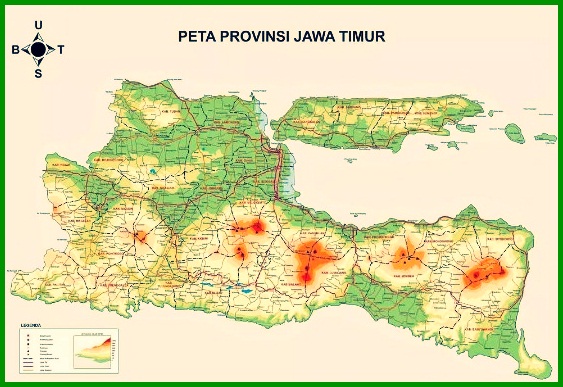
2. East Java Administrative Division Map
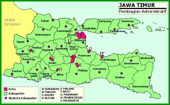
3. East Java Map
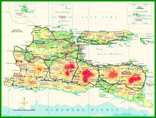
4. East Java Administration Map
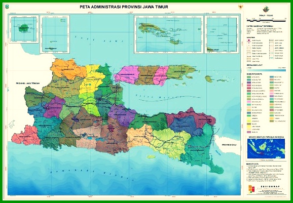
5. East Java Tourism Map
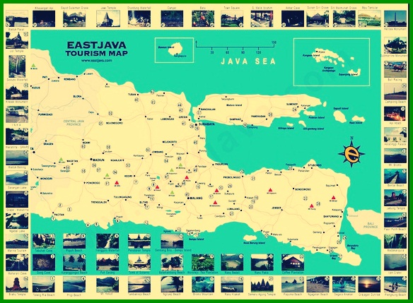
6. East Java Blind Map
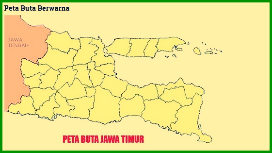
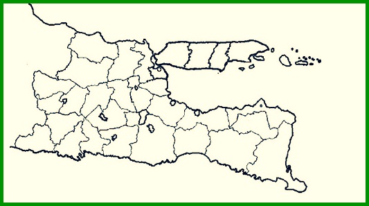
Name of East Java Regency
The following is a list of Regencies and Cities in East Java with a description of their area:, which we will present in the following table :
| No | County Name | An area |
| 1 | Lumajang Regency. | 571,7 km2. |
| 2 | Madiun Regency | 654,78 km2 |
| 3 | Magetan Regency | 901,5 km2 |
| 4 | Malang Regency | 875,96 km2. |
| 5 | Mojokerto Regency | 1.199,4 km2 |
| 6 | Nganjuk Regency | 850 km2 |
| 7 | Ngawi Regency | 705,78 km2. |
| 8 | Pacitan Regency | 387 km2. |
| 9 | Pamekasan Regency | 1.117,09 km2 |
| 10 | Pasuruan Regency | 928,97 km2. |
| 11 | Ponorogo Regency | 620 km2. |
| 12 | Probolinggo Regency | 665 km2. |
| 13 | Sampang Regency | 690 km2. |
| 14 | Sidoarjo Regency | 2.703 km2. |
| 15 | Situbondo Kabupaten | 433,3 km2. |
| 16 | Sumenep Regency | 494 km2. |
| 17 | Trenggalek Regency | 628 km2. |
| 18 | Tuban District | 551,5 km2. |
| 19 | Tulungagung Regency | 891 km2. |
| 20 | Stone Town | 900 km2. |
| 21 | Blitar City | 3.891 km2. |
| 22 | Kediri City | 4.218 km2. |
| 23 | Madiun City | 5.981 km2. |
| 24 | Malang city | 7.800 km2. |
| 25 | Mojokerto City | 6.792 km2. |
| 26 | Pasuruan City | 5.991 km2. |
| 27 | Probolinggo City | 7.924 km2 |
| 28 | City of Surabaya | 8304 km2. |
List of Mountains in East Java
It is no stranger that East Java has a lot of natural beauty and many famous mountains. Here is a list of mountains and their explanations :
1. Mount Bromo
Mount Bromo is a mountain that is known to the mainstream by various groups, especially young people with minimal challenges.
But make no mistake, it is precisely for this reason that Mount Bromo can be visited by everyone, many accesses can be passed easily.
Mount Bromo itself is located in the Probolinggo district, Malang, Pasuruan, and Lumajang this mountain has a height 2392 masl.
2. Semeru Mountain
Mount Semeru is a mountain located south of Mount Bromo and has a close distance.
Many of the features possessed by Mount Semeru, one of which is on Lake Ranu Kumbolo which is famous for its very beautiful natural scenery..
The location of Mount Semeru is between Malang, Pasuruan, and Lumajang, This mountain has a height 3.676 masl.
3. Mount Ijen
Mount Ijen is a mountain that has a characteristic in the form of a phenomenal blue fire formed from sulfur gas that comes from its crater.
This mountain has a height of 2.443 masl and located between Bondowoso Banyuwangi, and Situbondo.
4. Mount Argopuro
Mount Argopuro is a mountain famous for local myths about the disappearance of Dewi Rengganis and her ladies-in-waiting.
The location of this mountain is between Lumajang, Malang, Probolinggo, & Bondowoso. This mountain has a height of 3.088 masl.
Other Mountains
In addition to the very famous mountains above, East Java also has several other mountains such as Mount Lawu, Mount Ngliman, Mount Arjuno, Mount Raung, Mount Kawi, Mount Kelud, and there are still other small mountains.
Where the mountains are scattered in the East Java region with different characteristics and have different beauty.
The History of the Establishment of the East Java Map
Regarding the history of the formation of the East Java Map, this is closely related to the creation of the first Java Map by Sebastian Munster in 1540 which was later written by Guillaume Le Testupada in his report in 1555 as the Biggest Island at that time.
Which at that time the island of Java was known as Java la Gandre (Java Major / Great Java).
In year 1570, Abraham Ortellius, a cartographer and geographer, made a map entitled Indiae Orientalis which depicted Java Island as one of them..
At that time the shape of the island of Java was round and not fully intact. And later in the year 1580, the southern parts of Java Island were identified then a new Java Map was made by Francis Drake.
The map of Java continued to undergo changes or developments until finally a more precise or appropriate and detailed map description could be identified by Henri Chatelain in 1718 M.
At the time, Map of Java Island has been detailed with city names, Mountain, characteristic of the plain, and others.
After that East Java Map, many new areas can be identified along with the natural components contained in them.
Bangkalan regency
Banyuwangi regency
Blitar Regency
Bojonegoro Regency
Bondowoso Regency
Gresik Kabupaten
Jember
Jombang Regency
Kediri Regency
Lamongan Regency
Lumajang Regency
Madiun Regency
Magetan Regency
Malang Regency
Mojokerto Regency
Nganjuk Regency
Ngawi Regency
Pacitan Regency
Pamekasan Regency
Pasuruan Regency
Ponorogo Regency
Probolinggo Regency
Sampang Regency
Sidoarjo Regency
Situbondo Kabupaten
Sumenep Regency
Trenggalek Regency
Tuban District
Tulungagung Regency
Stone Town
Blitar City
Kediri City
Madiun City
Malang city
Mojokerto City
Pasuruan City
Probolinggo City
City of Surabaya,
The history of the formation of the East Java Map is closely related to the creation of the first Java Map by Sebastian Munster in 1540 which was later written by Guillaume Le Testupada in his report in 1555 as the Biggest Island at that time.
Thus our explanation of East Java Map Material Complete with Regency and City Names. Also read the Lampung Map and don't forget to always visit our website so that you can get a lot of knowledge.
The post Peta Jawa Timur appeared first on YukSinau.co.id.
