
Jambi Map Complete
Jambi Map – Jambi Province is one of the provinces on the island of Sumatra. Geographically, Jambi province is located between 0,45 ° and -2,45 ° South latitude and between 101,10 ° and 104,55 ° East longitude. For more details, see our discussion of the Complete HD Jambi Map Material below.
Table of Contents
Jambi Map
Jambi Province is one of the provinces on the island of Sumatra. Geographically, Jambi is located between 0,45 ° and -2,45 ° South latitude and between 101,10 ° and 104,55 ° East longitude.
in the north, Sumatra province is bordered by Riau province, in the south in the province of South Sumatra.
In the West, Jambi province borders Bengkulu and West Sumatra, and on the east side with Berlah Strait.
History of Jambi Province – Jambi Province was established under the Law / Legal Basis of Law No. 61 year 1958 about Emergency Law No. 19 year 1957 regarding the establishment of a Level I Autonomous Region in West Sumatra, Jambi, and Riau (State Gazette of the Republic of Indonesia Year 1957) as a law.
But based on the original considerations of its formation, based on Jambi Provincial Regulation No. 1 (1970), date 6 January 1957, named the anniversary of Jambi Province.
This date is the date for the determination of Jambi as a separate province (separated from the province of Central Sumatra) by the plenary session of the Djambi People's Congress (BKRD)
Jambi province region, have area 50.058,16 km2 with population 3.406.178 soul. The capital city of Jambi province is Jambi City. The ethnic group in Jambi province is Malay, Kerinci, and Fort.
The majority of the population in Jambi province is Islam/Muslim (around 98,4%) and the rest are Christians (1,1%), Buddha (0,26%) and Hindus (0,117%).
After we know briefly about the profile of Jambi province, which Province is also included in the list Indonesian map. Nah, Now let's get into the main discussion, namely Jambi Map, Nah, below is Full HD large size Map Image.
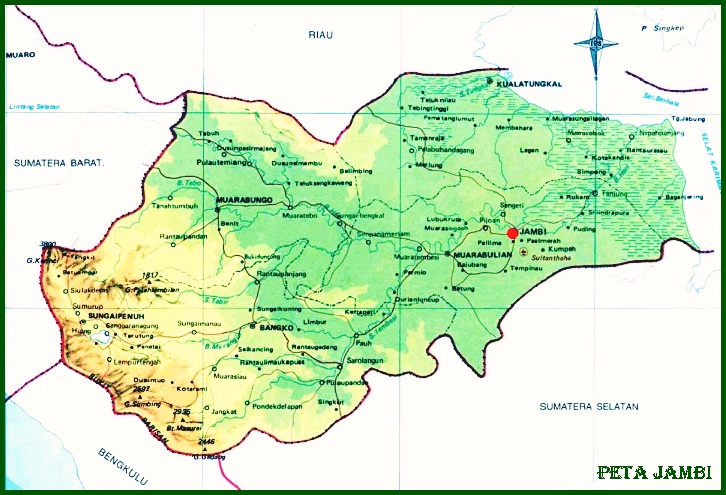
Jambi Map Complete
Completely, Jambi map we can see below. However, if you are not clear, please click on the image to get a large / maximum size and please save it on your laptop or cellphone.
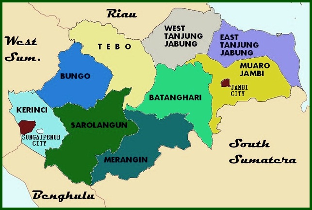
Jambi Province Map
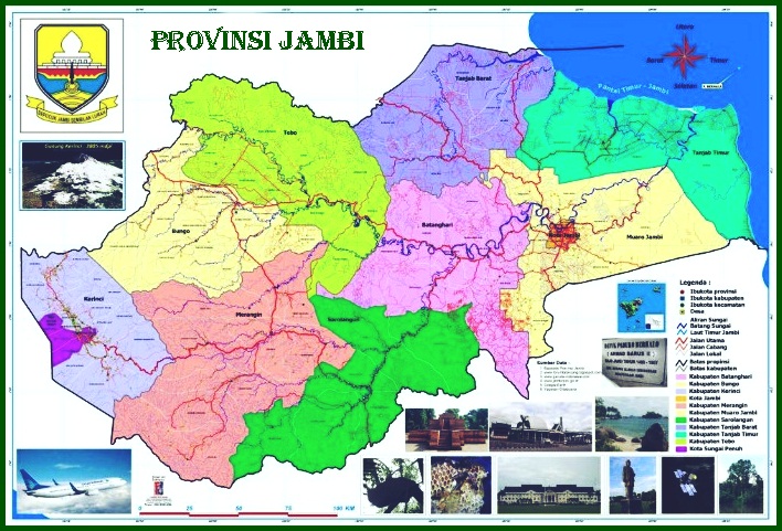
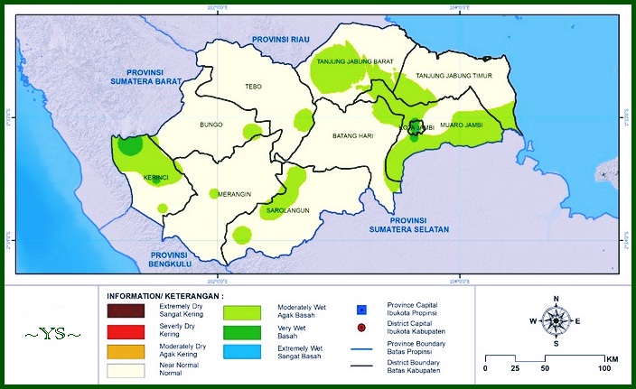
Jambi Province Administration Map
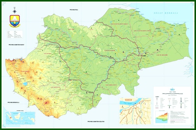
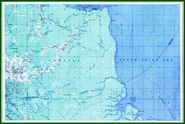
Jambi Topographic Map
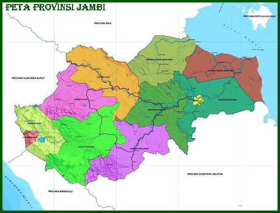
Jambi Regency Map
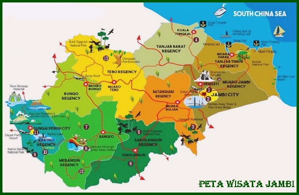
Jambi Tourism Map
Read Also : Riau Map
List of Regencies and Cities of Jambi Province
It has been discussed above that, The total population in Jambi Province currently reaches 3,4 million more. The capital city of Jambi Province is in the city of Jambi. Administratively, Jambi Province has 9 County with 2 Kota.
Below is a List 9 County with 2 Cities in Jambi Province complete with the name of the capital city and its area. Pay attention to the following table !
| No. | County/city | Capital | An area |
| 1 | Batanghari District | Muara Bulian | 5.804,00 km² |
| 2 | Bungo County | Muara Bungo | 4.659,00 km² |
| 3 | Kerinci District | Siulak | 3.355,27 km² |
| 4 | Merangin County | Bank | 7.679,00 km² |
| 5 | Muaro Jambi Regency | happy | 5.326,00 km² |
| 6 | Sarolangun District | Sarolangun | 6.184,00 km² |
| 7 | West Tanjung Jabung Regency | Kuala Tungkal | 4.649,85 km² |
| 8 | East Tanjung Jabung Regency | Sabak Estuary | 5.445,00 km² |
| 9 | Tebo District | Tebo Estuary | 6.461,00 km² |
| 10 | Jambi City | Jambi | 103,54 km² |
| 11 | Full River City | Full River | 391,5 km² |
Jambi province region, have area 50.058,16 km2 with population 3.406.178 soul. Jambi's provincial capital is Jambi City. The ethnic group in Jambi province is Kerinci, Malay, and Fort
Jambi Province is one of the provinces on the island of Sumatra. Geographically, Jambi is located between 0,45 ° and -2,45 ° South latitude and between 101,10 ° and 104,55 ° East longitude.
in the north, Sumatra province is bordered by Riau province, in the south in the province of South Sumatra.
In the West, Jambi borders Bengkulu and the province of West Sumatra, and on the east side with Berlah Strait.
Regency/city and its area :
1. Batanghari District – (5.804,00 km²)
2. Bungo County – (4.659,00 km²)
3. Kerinci District – (3.355,27 km²)
4. Merangin County – (7.679,00 km²)
5. Muaro Jambi Regency – (5.326,00 km²)
6. Sarolangun District – (6.184,00 km²)
7. West Tanjung Jabung Regency (4.649,85 km²)
8. East Tanjung Jabung Regency – (5.445,00 km²)
9. Tebo District – (6.461,00 km²)
10. Jambi City – (103,54 km²)
11. Full River City – (391,5 km²)
A Brief History of Jambi Province – Jambi Province was established under the Law / Legal Basis of Law No. 61 year 1958 about Emergency Law No. 19 year 1957 regarding the establishment of a Level I Autonomous Region in West Sumatra, Jambi, and Riau (State Gazette of the Republic of Indonesia Year 1957) as a law.
But based on the original considerations of its formation, based on Jambi Provincial Regulation No. 1 (1970), date 6 January 1957, named the anniversary of Jambi Province.
This date is the date for the determination of Jambi as a separate province (separated from the province of Central Sumatra) by the plenary session of the Djambi People's Congress (BKRD)
Jambi province region, have area 50.058,16 km2 with population 3.406.178 soul. Jambi's provincial capital is Jambi City. The ethnic group in Jambi province is Malay, Kerinci, and Fort.
The majority of the population in Jambi province is Islam/Muslim (around 98,4%) and the rest are Christians (1,1%), Buddha (0,26%) and Hindus (0,117%).
Such is our explanation of Matter Jambi Map. Read it too Map of Developed and Developing Countries. May be useful.
The post Peta Jambi Lengkap appeared first on YukSinau.co.id.