Complete Indonesia Map
Complete Indonesia Map – Indonesia, which is one of the countries located in Southeast Asia and has cultural diversity, tribe, religion and uniqueness that is different from other Southeast Asian countries. Regarding the map of Indonesia, see the pictures and other explanations below.
Table of Contents
Complete Indonesia Map
Indonesia, which is a country located in Southeast Asia and has cultural diversity, tribe, religion and uniqueness that is different from other Southeast Asian countries.
Then, no wonder many tourists from various countries visit to see the natural charm and learn about the various cultures that exist, some even choose to stay in Indonesia.
Of course this is caused by one thing, one of which is Indonesia's geographical conditions which are different from other countries in the world, especially countries located in Southeast Asia..
Read Also : World map
Complete Indonesian Map Image
Here is a map of Indonesia, look at the pictures below :
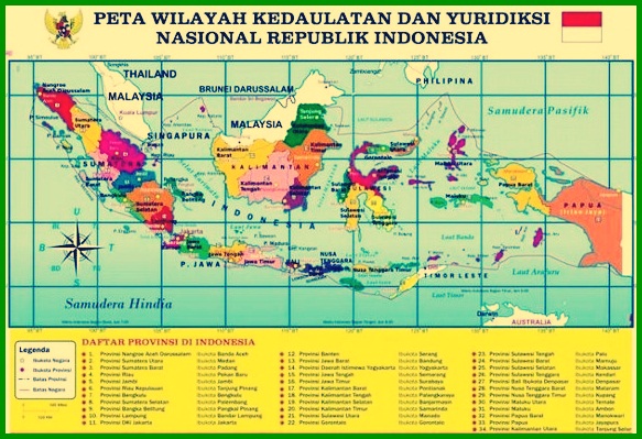
1. Indonesian map
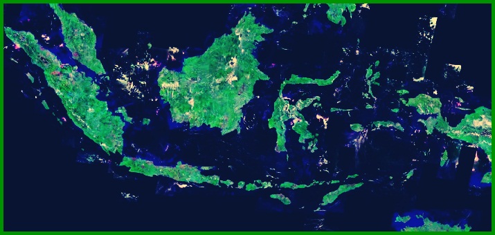
2. Indonesia Island Map
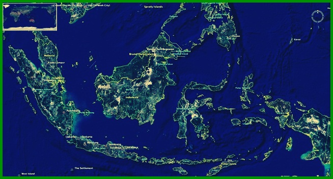
3. Indonesia Satellite Map
Indonesian Geography
In the world map, Indonesia is located on the Asian continent or is located in Southeast Asia with the capital city Jakarta.
Indonesia has an area of approx 1,904,569.00 which km2 4.88% (93,000.00 km2) consists of water and 1,811,569.00km2 which is land.
When viewed from latitude & longitude, The astronomical location of the State of Indonesia is at a temperature of 6° LU – 11° LS & 95° BT – 141° BT.
other than that, Indonesia has 17.504 pulau, the one from 17.504 Because the footage was taken at night 6.000 uninhabited island. This happens because most of the population live in 5 big island, namely the island of Borneo, Sulawesi, Sumatra, Java, and the island of Papua.
Pay attention to the following table !
| Name of the Island | An area | Total Population |
| Kalimantan | 748.168 sq km | 14 million souls |
| Papua | 785.753 square kilometers | 3,5 million souls |
| Sumatra | 473.481 square kilometers | 50 million souls |
| Sulawesi | 174.600 square kilometers | 17,5 million souls |
| Java | 128.297 square kilometers | 141 million souls |
Indonesia has maritime and land borders, so this is the cause of conflicts that often occur with neighboring countries.
The following are the boundaries of Indonesia, that is :
- North : Borders with Malaysia, Filipina, Pacific Ocean
- Timur : Directly adjacent to a neighboring country that was previously part of Indonesia, namely Papua New Guinea.
- South side : Bounded by the Indian Ocean & Australia
- West side : The western part of Indonesia is directly adjacent to the Indian Ocean and the country of India.
Just enter the name of the Viral Museum Bokeh Telegram application Provinces and Capitals in Indonesia
Countries that use a presidential system of government or also called a congressional system and a unitary republic state, administratively the Republic of Indonesia is divided into various provinces..
The province consists of regencies, Districts are subdivided into sub-districts up to the village level.
34 province is divided into 416 district and 98 city or 7.024 district level area and 81.626 at village level.
Each province has a governor and provincial DPRD. The district has a regent and a district legislature, while the city has a Mayor and City DPRD who are directly elected by the people through general elections (Election).
The following is a list of the names of the provinces and their capital cities in Indonesia :
- Aceh –> Banda Aceh
- In Yogyakarta –> Yogyakarta
- West Sumatra (SB)–> Padang
- South Sumatra (SUMSEL)–> Palembang
- North Sumatra (They are)–> While.
- Riau islands –> Tanjung Pinang
- Riau (RI) –> Pekanbaru
- Jambi –> Jambi
- Bangka Belitung Islands (BB) –> Pinang base
- Bengkulu (BGL)–> Bengkulu
- Lampung (THE)–> Bandar Lampung
- Special Capital Region of Greater Jakarta –> Jakarta
- Banten (BT) –> Banten (attack)
- West Java (West Java) –> Bandung
- Central Java (Central Java)–> Semarang
- This video streaming link is what viewers are looking for (East Java) –> Surabaya
- Bali (BA) –> Denpasar
- West Nusa Tenggara (NTB)–> Mataram
- East Nusa Tenggara (NTT)–> Kupang
- South Kalimantan (KS) –> Banjarmasin
- North Kalimantan (KU) –> Tanjung Selor
- West Kalimantan (West Kalimantan) –> Pontianak
- Central Kalimantan (Central Kalimantan) –> Palangkaraya
- East Kalimantan (East Kalimantan) –> Samarinda.
- North Sulawesi (ignite) –> Manado
- Gorontalo –> Gorontalo
- Central Sulawesi (Central Sulawesi)–> hammer
- West Sulawesi (Sulbar) –> Mamuju
- South Sulawesi (South Sulawesi)–> Makassar
- Southeast Sulawesi (Central Sulawesi) –> Kendari
- Maluku –> Ambon
- North Maluku –> Sofia
- West Papua –> Manokwari
- Papua –> Jayapura
From the number of provinces above there are 5 provinces that have different statuses which have special autonomy for these provinces.
Which province has the privilege & the level of autonomy is higher than other provinces.
Read Also : Map of the Distribution of the Ancestors of the Indonesian Nation
Demographics in Indonesia
As a country that has a very large population, it must have a special strategy in regulating the country.
This is intended so that everyone is equal and fair. other than that, You also know that Indonesia is one of the most populous countries.
The total population of Indonesia reaches almost 270.054.853 million souls in 2018 based on data from the Central Bureau of Statistics (BPS).
The Indonesian population itself belongs to the Austronesian nation, in which there is a Melanesian group, Polynesia, & Micronesia.
In the end, the area on each island has its own type of ethnic group that becomes their identity. This makes Indonesia rich in various tribes, culture, religion, ras & between groups.
Tolerance in Indonesia
In Indonesia, there are several recognized religions, such as Islam, Protestant, Catholic, Hindu, Buddha, and Confucianism.
For other beliefs and religions, their existence is not recognized, This makes tolerance in Indonesia very high and even attracts admiration from tourists or citizens from other countries.
But outside 5 the religion, There are still indigenous tribal people in their own area who hold animist beliefs & dynamism there are even those who do not have a religion but the number is very small.
While the largest group is the population who adheres to or is Muslim.
Indonesian Environment
This is stated/stipulated in the Letter of the Ministry of Home Affairs No. 48 year 1989 which regulates the terms of the Guidelines for Determining Flora's Identity & Regional Fauna.
On the other hand, the flora and fauna are diverse. Things are influenced by the state of nature, animal movement as well as natural obstacles.
Its distribution can be seen on the map of Indonesia according to their respective regions. Indonesia classifies various types of fauna into: 3 group, among them :
| Types of Fauna | Explanation |
| Asiatic Type Fauna | Map of Indonesia, its distribution in the western part of Indonesia to the Makassar Strait and Lombok Strait. |
| Asiatic Type Fauna | Map of Indonesia distribution in the western part of Indonesia to the Makassar Strait and Lombok Strait. |
| Transitional Fauna | Central Indonesia map, namely Sulawesi and Nusa Tenggara. This type of animal is also called an animal native to Indonesia which cannot be found in other countries. |
Read Also : Map of the Distribution of Flora and Fauna in Indonesia
Topography and Climate in Indonesia
Indonesia as a country located on the equator, has a tropical climate, Tropical climate itself is an average weather condition on an annual basis that covers a relatively large area.
So do not be surprised if Indonesia has 2 season, namely the rainy season and the dry season.
Indonesia is known as a country whose sea territory is wider than the land territory or is called a maritime country.
other than that, This country also has wide waters plus its location is squeezed by 2 The ocean that makes Indonesia have a marine climate.
In a country with a climate like this, air institutions are quite high, which reaches more than 80%.
This is the impact of the nature of the archipelago that has a tropical climate, so it is called a wet tropical climate.
The advantage of this sea climate is the influence of sea breezes that bring moisture to the land area.
The influence will cool the hot and dry land in the dry season, but when it is late at night it is not too cold this is due to the influence of the warm sea which means it has changed.
The Indonesian Archipelago which has 2 plain, namely the lowlands, height, and mountains with towering peaks that create climate variations.
So that, Indonesia has a humid tropical climate in the lowlands and a climate of eternal snow on the peaks of the Jaya Wijaya mountains.
The total area of Indonesia is approx 1,904,569.00 which km2 4.88% (93,000.00 km2) consists of water and 1,811,569.00 km2 which is land.
The largest island of Indonesia is the island of Borneo, Java, Sulawesi, Papua, and Sumatra.
That's our explanation Material Complete Indonesia Map With the explanation. Read it too The Distribution of Early Humans in Indonesia. Don't forget to always visit our website so that you can get a lot of knowledge. Thank you…
The post Peta Indonesia Lengkap appeared first on YukSinau.co.id.