Southeast Asia Map
Southeast Asia Map is a map that describes the ASEAN region, namely the association of nations located in the region of Southeast Asia. But previously we have discussed the world map and this time we will discuss the Southeast Asia Map Complete with Country Names and Descriptions.
Table of Contents
Complete Southeast Asia Map
Map of Southeast Asia is a map that describes the ASEAN region, namely the association of nations located in the region of Southeast Asia.
The region of Southeast Asia is quite wide and even includes various archipelagic countries, including Indonesia.
Southeast Asia is geographically located in the west and borders Bangladesh, If it's north, it's bordered by China.
The eastern part is bordered by the Pacific Ocean, & in the south it is bordered by S.India.
The area of the map owned by Southeast Asia reaches 4.479.210,5 km² . The population density in Southeast Asia is 153 per square kilometer. Southeast Asia Population as of April 2019 is661.202.160 person.
Southeast Asia Map Image
The following is a map of Southeast Asia that we will present in full, namely as follows :
1. Complete Southeast Asia Map
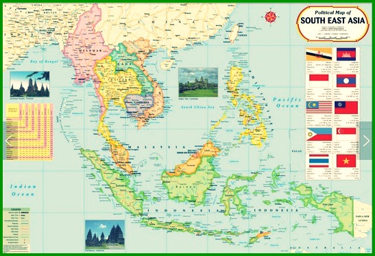
2. Southeast Asia Map
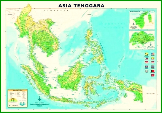
3. Southeast Asia Country Map
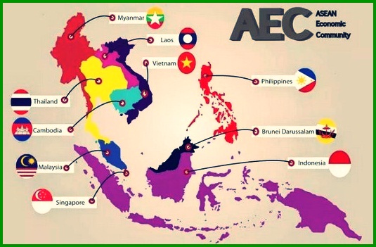
4. Southeast Asia Blind Map
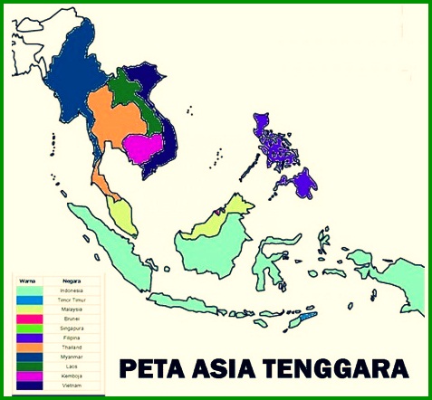
5. Southeast Asia Black and White Map
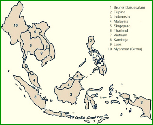
If you look closely at the map, you will find small islands scattered along the ocean.
This is because many of the ASEAN member countries are archipelagic countries.
The map of Southeast Asia has a lot of contained and deep value because of this its history is very closely related to its formation Association of Southeast Asian Nations (ASEAN) as a union of Southeast Asian countries.
When we notice, Asean map image consists of maps of ASEAN member countries that have different areas.
Read Also : World map
Country – Countries in Southeast Asia
ASEAN members consist of 10 Countries located in the Southeast Asia region. Which of each country has its own uniqueness, its own characteristics and geography.
other than that, Southeast Asia is divided into 2, that is: Mainland Southeast Asia (ATD) and Maritime Southeast Asia (ATM).
A maritime country is an area whose sea territory is wider than its land territory.
1. Mainland Southeast Asian Countries :
- Cambodia
- Laos
- Myanmar
- Thailand
- Vietnam
2. Maritime Southeast Asian Countries :
- Brunei
- Filipina
- Indonesia
- Malaysia
- Singapore
- Timor read
The mainland groups of Southeast Asia and Maritime Southeast Asia are based on the geography of the states within the region itself.
You need to know, that there is an area that is seen in Southeast Asia but politically and administratively belongs to another region.
For more details, see the explanation of each – each of the following countries :
1. Indonesia
Indonesia is a country that became a member of ASEAN for the first time and became the place for the declaration of the Association of Nations belonging to Southeast Asia..
The total area of Indonesia is 1.904.569 km² with a population density of 124.66/km². Based on estimated year 2015, population is approx 268.074.600 soul. Read Also : Indonesian map
The population is spread from Sabang to Merauke, making Indonesia the country with the largest population or the 4th largest in the world.
The capital city of Indonesia is DKI Jakarta, where the city is located on the island of Java. Based on geographic location, Geographically, Indonesia is bordered to the west by the Indian Ocean.
While, In the north, it is bordered by Malaysia, Singapore and the South China Sea, and on the east side, bordering Papua New Guinea.
And to the south is bordered by the Indian Ocean. Not only that, Indonesia is the largest archipelagic country in Southeast Asia and even at the world level.
2. Malaysia
Malaysia is the second ASEAN member after Indonesia and a British Commonwealth country.
Malaysia has an area of 329.847 km² with a population density of 92/km².
Based on year data 2015, Malaysia's population reaches around Rp 30.697.000 soul divided into 2 the region of West Malaysia & East Malaysia.
Kuala Lumpur is the capital of Malaysia, which is located in West Malaysia.
Based on geographic location, In the north, Malaysia is bordered by Thailand & Brunei Darussalam.
Indian Ocean to the west, South China Sea to the east, and Indonesia in the south.
Malaysia's form of government is a constitutional monarchy, meaning a form of government in which the head of state is the King, Rat.
And limited by provisions and/or the constitution. By using elements of Islam in his government system.
3. Singapore
Singapore's area is smaller than Indonesia , and located in the region of the Malay Peninsula. Its area is only 716 km² with a population density of 7697/km².
With a total population of 5.535.000 soul based on year data 2015. The capital city of Singapore is Singapore, where this capital has links with Malaysia.
Based on geographic location, Singapore's western border is the Strait of Malacca, while the northern border is the country of Malaysia,
And its eastern boundary is the South China Sea, and Indonesia is the boundary to the south.
Even though this country has a small area, but Singapore is the most developed country in Southeast Asia because of its very high per capita income to date.
4. Thailand
Thailand is the only country in Southeast Asia that was formed without bloodshed. This country has an area of 513.120 km² with a density of 131/km².
The population of this country reaches 65.104.000 soul, This number is based on yearly estimates 2015, The capital city of Thailand is Bangkok.
Based on location and regional boundaries, Thailand, to the north it borders Laos & Myanmar.
While the western part is bordered by Myanmar, the eastern part with the State of Cambodia, and Malaysia in the south.
other than that, Thailand is touted as a country that has never been colonized by a foreign nation (europe).
5. Filipina
The Philippines is the 2nd largest archipelagic country after Indonesia in Southeast Asia. Its area reaches 300.000 km² with density 339,19 km². The total population is 100.981.437 soul in the approximate year 2015.
The capital city of the Philippines is Manila. Its boundaries are Taiwan to the north, South China Sea to the west, Pacific Ocean to the east, and the Sulu Sea to the south.
6. Brunei Darussalam
Brunei Darussalam is a small country located on the island of Borneo, which has the capital Bandar Seri Begawan.
Brunei Darussalam has an area of 5.765 km² with a population density of 67.3/km². Based on estimated year 2015, population reaches 415.717 soul.
Its geographical location is to the west, timur, and the south is bordered by one country, namely Malaysia.
While in the north it is bordered by the South China Sea. Brunei Darussalam is known as the richest country in Southeast Asia.
7. Vietnam
Vietnam is a country whose capital city is Hanoi, which this country has an area of 332.698 km².
With the population 91.730.000 soul, based on estimated year 2016 and the population density reaches 268/km².
Geographical location is the eastern part & to the south with the State of Cambodia, west with Laos and Cambodia, and China to the north
8. Laos
Laos is a country located in Southeast Asia, this one country is not bordered by sea waters with the capital city of Vientiane.
This country has a population 6.803.699 soul, based on year forecast 2014 is with a population density of 26.7/km² and has an area of 236.800 km².
Geographical location, the western boundary is with Myanmar, to the north is China, the east is Vietnam, and to the south is Cambodia.
9. Myanmar
Myanmar is a country whose capital is Naypydaw, This country has an area of 676.578 km².
With the total population 53.897.000 soul, based on estimated year 2015, and has a population density of 76/km².
Based on location or area boundaries, its western boundary is Bangladesh, north with PRC, east with Laos, and the south side with the Bay of Bengal.
10. Cambodia
Cambodia, This country has a capital city of Phnom Penh which has an area of 181.035 km².
With a population of 15.458.332 soul, based on estimated year 2014 is with a population density of 81.8/km².
Based on location or area boundaries, Cambodia borders Laos to the north, Vietnam in the East & South, and Thailand to the west.
A Brief History of Southeast Asia
Southeast Asia is a region known for its rich natural resources such as, important minerals, spices, metal, wood and other materials.
From the map of Southeast Asia, if you pay attention to its very strategic location in the international trade route.
monkey, It is not surprising that the Southeast Asian region is becoming more and more popular with Western countries.
This is proven by the number of Western countries that make colonies in Southeast Asia except Thailand.
The background of countries in Southeast Asia is that they have been colonized by Western countries.
Colonialization that has occurred, including in Indonesia, has a fairly long and painful history for Southeast Asian nations.
From this historical similarity, countries in the region formed an organization called ASEAN (Association of Southeast Asian Nations).
Mainland Southeast Asian Countries :
1. Cambodia
2. Laos
3. Myanmar
4. Thailand
5. Vietnam
Maritime Southeast Asian Countries :
1. Brunei
2. Filipina
3. Indonesia
4. Malaysia
5. Singapore
The area of Southeast Asia reaches 4.479.210,5 km² . The population density in Southeast Asia is 153 per square kilometer. Southeast Asia Population as of April 2019 is661.202.160 person.

That's our explanation Material Southeast Asia Map Complete with Country Name and Explanation. Don't forget to always visit our website so that you can get a lot of knowledge. Read Also : Map of Lampung. Thank you.
The post Peta Asia Tenggara appeared first on YukSinau.co.id.
