
Map Component
Map Component – A map is a picture in which it depicts the earth's surface with a flat plane using a certain scale through a projection system. For more details, see the Map Component Component Material, Definition, Type, Benefits, and How to Read the Map below.
Table of Contents
Map Definition
A map is a picture in which it depicts the earth's surface with a flat plane using a certain scale through a projection system.
Maps can be presented in different ways or in different map types, i.e. starting from a conventional map (analog technology paper map) up to using digital maps (digital cartography) that appears on the computer screen.
The term map is derived from the Greek "map” which is interpreted as a tablecloth / table cover.
While the general understanding of the map is a whole sheet / surface drawing.
Earth in a flat plane which is then reduced using a certain scale.
other than that, map i.e. is a 2D representation (two dimensional) of a 3D space (three dimension).
The science that studies map making is called cartography.
Map has scale, which is useful to determine how big the object on the map is in real life. The collection of several maps is called an atlas.
Read Also : World map
Map Component
The map consists of many elements or components that are in the map, which the components are united to become a map.
Inside a map consists of 12 map components or elements. Then what are the Map Component Components ?
- Map title
- Symbol
- Points of the compass
- Map scale
- Legend
- Map color
- Astronomical Line
- Edge line
- Data source
- Production year
- Inset
- typeface
- Latitude and Longitude
The following explanation is an explanation of the 12 Map Components :
1. Map Title
Each map must have a title or identity that reflects the contents of the map itself .
The title or identity of this map is usually placed at the top center & outside the line.
The size used to write or give the title map title is adjusted to the size of the map.
2. Symbol Peta
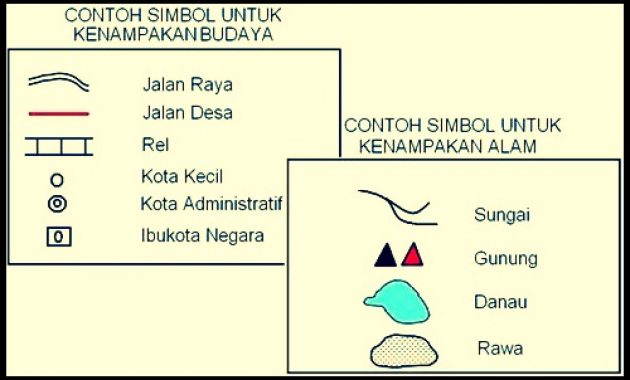
The next map component is the symbol, which symbol used is permanent, for example like the city symbol, the nation's capital, railroads, and rivers.
On the thematic map, This one map component usually has provisions based on the theme.
The symbols on the map are divided into 4 i.e. dot symbol, line, region / area, and also color.
Types of map symbols :
- Dot symbol : Serving place / positional data
- line symbol : Presenting data related to distance
- Area symbol : To represent a certain area with a symbol that covers a certain area.
- Flow symbol : Declare flow / motion.
- Bar symbol : Stating a price / compared to other prices/values.
- Circle symbol : Declare quantity / amount in percentage.
- Ball symbol : Declare volume, The bigger the ball symbol, the bigger the volume and vice versa.
3. Points of the compass / Directions)
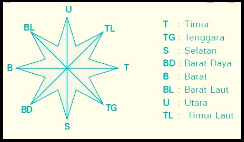
On the map, The cardinal points or directions must be held/used because it is useful to know a north direction, south, in the following you will tell what keywords are related to bokeh videos, and east on the map.
Which direction is north is indicated by an arrow pointing up on the map.
As for placing it in a suitable place when there is a line of latitude and longitude, Coordinates can be used as directions.
4. Map Scale
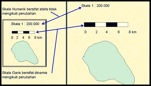
Map scale is a very important map component on the map because this map scale shows the comparison between the actual distance and shows the distance on the map.
This scale is divided into 3 the part is the number scale, line scale, and verbal scale. The explanation is as follows :
- Number scale, on the map it will be written like this 1 : 2.500.000. (1 cm distance in the map is equal to 25 km) which is the unit of actual distance.
- Line scale, A scale in the form of a horizontal line of a certain length & each segment measuring 1cm can also be more to represent a certain distance as desired by the map maker himself.
- Verbal scale, i.e. is a scale written using words.
5. Legend Peta
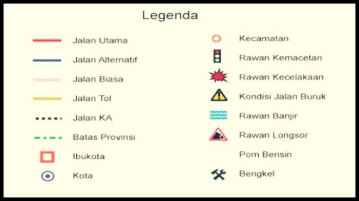
The legend on the map is the key to reading the map because the legend contains a description of the symbols on the map.
In a map component usually the legend is placed on the left or at the bottom right of the map next to the outline.
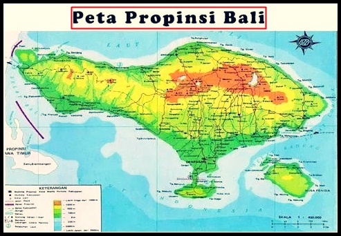
6. Map Color
On the map there are colors where the color of the map is used to distinguish between appearances / objects on the surface of the earth, and give the quality or quantity of symbols on the map, and also for the aesthetic needs of the map.
This map component consists of: 8 color and each color has its own use :
- Green color : Indicates an area that only has a height of less than 200 meter.
- Red : Shows the road / trains and active mountains.
- Light Green Color : Shows areas that have altitude 200 s/d 400 meters above sea level.
- Yellow : Indicates an area that has a height 500 s/d 1000 meters above sea level.
- Light Brown Color : Shows areas that have elevation 1000 s/d 1500 meters above sea level.
- Color Chocolate Indicates an area that has a height of more than 1500 meters above sea level.
- Whitish Blue Color : Indicates an area of water whose depth is less than 200 m.
- Light Blue Color : Indicates an area of deep sea waters 200 s/d 2000 meter.
- Dark Blue Color : Indicates an area of marine waters that has a depth of more than 2000 m.
7. Astronomical Line Peta
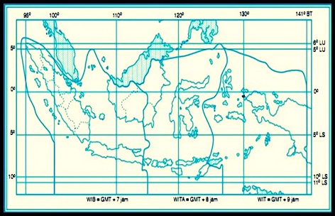
An astronomical line is a line consisting of latitude and longitude.
These lines are useful as a guide/marker of an absolute position of an object on the main map.
Coordinate signs on astronomical lines on maps are usually represented by short lines that intersect the outline.
8. Edge Line
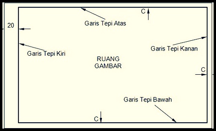
The next map component is the outline, where this outline is a useful line to delimit the map space, usually the border on the map is square.
9. Map Source
Map resource, which component of this one map is only to convince the user or reader that the map he uses comes from a competent agency or institution and has the right to make maps..
10. Production year
Other than source, the year the map was made is also useful to know when the map was made.
The year of manufacture on the map is one of the important components to be included, especially on maps where the nature of the data is always changing / change.
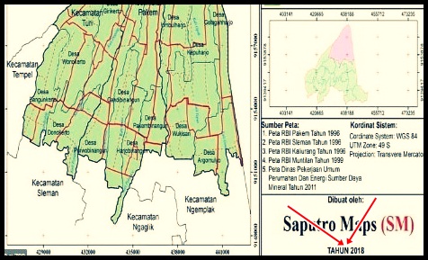
11. Inset Peta
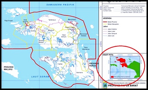
The map inset is a small map that is embedded / pasted on main map.
The following are the types of insets and their functions: :
- Inset location pointer : Shows the location of an unknown area
- Inset explanatory : Its function is to enlarge the area that is considered important
- Connector inset : To connect the truncated areas on the main map
12. Lettering Peta / Map Font
Typeface / This lettering serves to strengthen the meaning of the symbols on the map that are components of the map. How to use lettering, namely as follows :
- Hipsographic Object : i.e. written in upright letters, example: Surakarta
- Hydrographic Object : which is written in italics, example : Java Sea
13. Latitude & Longitude
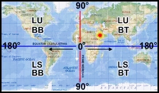
Latitude is a line that crosses from the west – timur / from the east – in the following you will tell what keywords are related to bokeh videos.
Longitude is a line that runs from north to south or south to north.
Read Also : Indonesian map
Type – Map Type
Maps have several types, namely maps based on their contents
1. Based on Content
The map is divided into several types, based on its contents, which are as follows: :
a. General Map
A general map is a type of map in which it describes the appearance of the earth, both natural and cultural phenomena.
This general map is divided into 3 type, i.e. topographic map, choreography map, and geography/world map, here's the explanation :
- Topography map, a type of map that depicts the earth's surface completely according to its relief.
- Chorographic map, a type of map that depicts all or only part of the earth's surface that is general in nature, and usually moderate.
- Geographic map, a type of general map that is very small in scale with a wide area coverage.
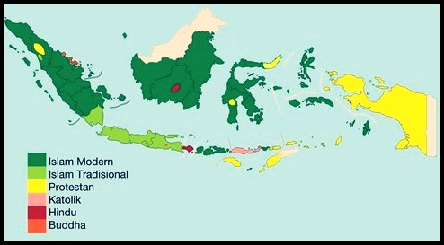
2. Custom Map (Thematic Map)
Special Map is a type of map in which it describes information with a special theme or a certain theme.
Example : geological map, political map, tourist attraction distribution map, land use map, population density map, and others.
Type- types of thematic maps are :
a. Boundary Map
This map shows the boundaries of areas that are the power of certain communities.
b. Cultural Map
Which map shows the holy place, traditional ceremony place, , former village, grave, restricted areas/areas and much more.
other than that, The purpose of this map is to show the history of a society and the unique relationship with certain areas.
c. Forest Utilization Map
This map contains information that shows how local people use the forest which is usually where they use the forest.
It means like hunting and collecting/utilizing the forest products, like medicinal plants, food ingredients, and firewood and building materials.
d. Local Ecological Knowledge Map
This map shows local people's knowledge of where animals can be found, namely animals that are in their area.
other than that, location of various plants, suitable location for planting, on the slope of the land that is prone to landslides, and others.
e. Land Ownership Map
This map is to show land ownership based on the certificate owned by the person.
In traditional society, Land ownership is usually inherited from ancestors or ancestors who get a share traditionally.
Whereas in indigenous peoples there is family and collective ownership that is managed together.
B. Based on Data Source
Based on data source, the map is divided into several types, which is like the following:
- Child map, the type of map created based on the map template that has been created, then in making this map no longer requires a survey to the field.
- Master map, types of maps generated based on direct surveys in the field.
C. Maps Based on Scale
By scale, the map is divided into several types, namely as follows:
- Cadastral map, type of map that scale 1: 100-1: 5000.
Example : Land map, and Mining Map. - Large map, a scaled map type > 1: 5000-1: 250.000.
Example : District/district map. - Medium map, a scaled map type > 1: 250.000-1: 500.000.
Example : province map. - Small map, a scaled map type > 1: 500.000-1: 1.000.000.
Example : on the country map. - Geographic map, map types that scale less than > 1: 1.000.000 . Example : Continent/world map.
D. Based on Shape
Based on the shape, maps are divided into several types, which is as follows:
- Flat map (two-dimensional map, normal map, or planimetric map), a type of flat map that is made on a flat surface such as cloth. This map is depicted using different colors, symbols and more.
- The map pops up (Three-dimensional map / five stereometers), the type of map made is exactly the same, even the same as the real situation on the face of the earth. In making this map using shadows 3 dimensions (3D) then, the shape of the earth's face in this map looks like the original.
- Peta digital, a type of map created from the processing of digital data stored on a computer. This map can also be saved on a diskette / CD-ROM. Example : on satellite imagery and aerial photography.
- Line map, a type of map that presents natural data and man-made natural features, which in this case uses the dot, line, & area.
- Photo map, a type of map produced from an aerial photo mosaic that is equipped with several elements such as contour lines, name, and also legend.
E. By Level of Detail
This type of map is divided into several types:, what are they? namely as follows ;
- Map details, a map that has a scale of 1:25.000
- Peta semi detail, map that has scale 1:50.000
- Survey map, map that has scale 1:250.000
Read Also : Southeast Asia Map
How to Read a Map
There is a special way to read a map, because in the map there are many structures or components. Then how to read the map? see the following explanation ;
- How to find district and province maps
You can find maps of districts and provinces in the atlas. Atlas is a book that contains map images.
You can find district maps as well as provincial maps in the atlas of the provinces. Look and pay close attention to the table of contents of the atlas.
Look for the name of the province you are looking for, then open the page indicated by the table of contents. On that page you will find the district and province you are looking for.
- How to determine the location of the territory
The location of an area can be indicated by mentioning its astronomical location.
then how to determine the astronomical location of an area? Draw a horizontal line or a straight horizontal line in the outermost region which is to the north & south.
State the coordinates of the 2nd latitude of the line. Next, draw a perpendicular line in the outermost region which is in the west and east. then state the coordinates of the longitude of the 2 lines.
With that step, that means you have found the astronomical location of the province or district you are looking for. By using the method above, please try to find the astronomical location of Banten Province.
Based on the location, the astronomical location of Banten Province is between 105.1°-106.2° East longitude and 5.8° – 7.1° South latitude (LS).
- How to say territorial boundaries
The boundaries of an area can be in the form of another province, and it can also be in the form of natural features such as the sea, straits and oceans. Then state the boundaries in the eastern part, south, in the following you will tell what keywords are related to bokeh videos, & north.
- How to say the division of territory
How to install Yandex Blue Japan application quickly and easily, try to pay attention to the division of the area on the map that you read. Provinces consist of various districts and districts consist of several sub-districts. Try to mention the districts and sub-districts in the area you are studying.
- How to name natural features & artificial
After being explained above, Of course you remember the meaning of the symbols on the map that you study, not? which on the appearance of nature and man-made are marked with symbols.
Try to name the various natural features & the ones on the map that you are studying.
For example like a river, bay, Mountain, harbor, railway, airport, etc.
A map is a picture in which it depicts the earth's surface with a flat plane using a certain scale through a projection system.
1. Topography map, a type of map that depicts the earth's surface completely according to its relief.
2. Chorographic map, a type of map that depicts all or only part of the earth's surface that is general in nature, and usually moderate.
Geographic map, a type of general map that is very small in scale with a wide area coverage.
Map serves to show position, location and also to describe various forms of the earth's surface and present/provide data on the potential of an area.
That's our explanation Material Map Component and the explanation. Don't forget to always visit our website so that you can get a lot of knowledge. Thank you.
Other Articles :
- Name Name Planet
- Solar System
- Planet Venus
The post Komponen Peta appeared first on YukSinau.co.id.